Chad Google maps and Driving Directions
Get free driving directions, Google maps, traffic information for Chad, and N’Djamena (GPS: 12 06 N 15 02 E), the capital city of the country located in (the) Central Africa, south of Libya.
Find any address in N’Djamena on the Google map of Chad (CD) with ease or calculate your up to date itinerary to and from Chad or its neighboring counties like Cameroon, Central African Republic, Libya, Niger, Nigeria, Sudan.
Sightseeing and exploring in Africa starts here, thanks to Google because its Earth Engine combines a multi-petabyte catalog of updated satellite imagery and geospatial datasets with planetary-scale analysis capabilities. Wonder the world, use the satellite map function of the Google maps to explore or see differences on the Earth’s surface, inland, or the surrounding areas of Chad.
Google Maps Chad
Landlocked in north-central Africa, Chad has had a turbulent history since independence from France in 1960. Intermittent periods of civil war followed a military coup in 1975.
Chad is broad, arid plains in center, desert in north, mountains in northwest, lowlands in south.
The map above fully covers Chad with its road routes from cities to towns, road intersections in any region, provinces, prefectures, also with free driving directions in N’Djamena or to the neighboring towns and countries. To look at the detailed map about a particular quarter in N’Djamena, please click on the area and zoom to the place you are interested in the Google maps of Chad (CD).
Be creative, use the extras of this Google map; This is a detailed, clear, zoomable, large road map of Chad with its administrative divisions; 23 regions (regions, singular – region); Barh el Gazel, Batha, Borkou, Chari-Baguirmi, Ennedi-Est, Ennedi-Ouest, Guera, Hadjer-Lamis, Kanem, Lac, Logone Occidental, Logone Oriental, Mandoul, Mayo-Kebbi Est, Mayo-Kebbi Ouest, Moyen-Chari, Ouaddai, Salamat, Sila, Tandjile, Tibesti, Ville de N’Djamena, Wadi Fira.
The interactive map above is also may be used as the satellite map of Chad, or as a reverse search map for finding an address from its GPS coordinates.
A landlocked country in north-central Africa, Chad is about 85% the size of Alaska. Its neighbors are Niger, Libya, the Sudan, the Central African Republic, Cameroon, and Nigeria. Lake Chad, from which the country gets its name, lies on the western border with Niger and Nigeria. In the north is a desert that runs into the Sahara.
Chad (area: 1 284 000 sq km / 495 754,97 sq mi), where the official language is Arabic, French, lying in Africa and using the currency; Central African CFA franc (XAF), set their clock to UTC+1. That means they are 6 hours ahead of Washington DC during Standard Time in N’Djamena, the capital. Note to the time difference: N/A.
The climate in Chad; Three distinct zones: desert in north, semiarid region in center, and tropics in south.
Geography in a nutshell; Mostly plateaus sloping west-ward to Lake Chad. Northern third is Sahara. Tibesti Mountains in north rise to 10,826 ft (3300 m).
Click here for more detailed information about Chad.
Driving directions Chad
The Google maps and Google Satellite maps of Chad above showing the country, located next to Cameroon, Central African Republic, Libya, Niger, Nigeria, Sudan. For your further reference, the latitude and longitude coordinates of Chad are 15 00 N, 19 00 E , while the capital, N’Djamena found at 12 06 N 15 02 E.
When you are traveling around Chad, N’Djamena, or its other cities, use this routing tool, providing up to date route planning service free of charge.
Look no further; get accurate driving directions in Chad, Africa, by filling the route planner form below.
Since Google acquired and introduced its digitalized maps in 2004, you’re probably familiar with its base functions, like finding an address or driving directions to locations. Still, Google maps also accommodate bicyclists, pedestrians, and also public transportation with special directions and customizable routes.
About Chad and the capital, N’Djamena
 |
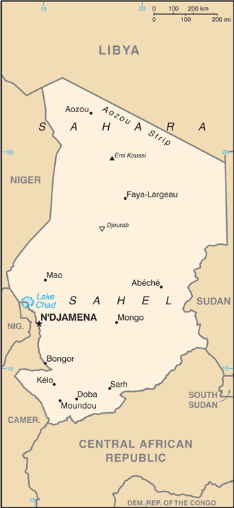 |
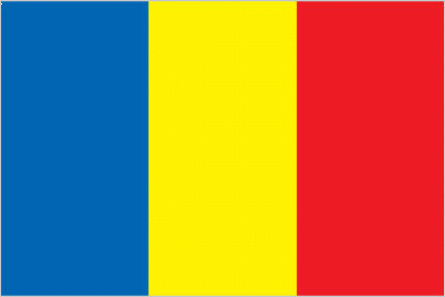
| The national flag of Chad | Borderline map of Chad |
| Flag description: three equal vertical bands of blue (hoist side), yellow, and red; the flag combines the blue and red French (former colonial) colors with the red and yellow of the Pan-African colors; blue symbolizes the sky, hope, and the south of the country, which is relatively well-watered; yellow represents the sun, as well as the desert in the north of the country; red stands for progress, unity, and sacrifice. Note: similar to the flag of Romania; also similar to the flags of Andorra and Moldova, both of which have a national coat of arms centered in the yellow band; design was based on the flag of France. | Border length: total: 6,406 km. Border countries (total: 6): Cameroon 1,116 km, Central African Republic 1,556 km, Libya 1,050 km, Niger 1,196 km, Nigeria 85 km, Sudan 1,403 km. |
Did you know about Chad?
- Chad became an autonomous republic in 1958 and for two years joined with Niger, Ivory Coast and Dahomey in the informal Sahel-Benin Union.
- Lake Chad is slowly drying up it is now estimated to be just 10% of the size it was in 1970.
- Chad shares its name with the shrinking lake where Cameroon, Niger, Nigeria, and Chad all meet. Due to serious droughts, Lake Chad today is just a tenth of its original size.
Facts of Chad (CD)
Name conventional long form: Republic of Chad, conventional short form: Chad, local long form: Republique du Tchad/Jumhuriyat Tshad, local short form: Tchad/Tshad, etymology: named for Lake Chad, which lies along the country’s western border; the word “tsade” means “large body of water” or “lake” in several local native languages
Codes: ISO; CD, Internet; .td
Capital city: N’Djamena
Language(s): French (official language), Arabic (official language), Sara (in south), more than 120 different languages and dialects
National holiday(s): Independence Day, 11 August (1960)
Motto: Unité, Travail, Progrés (Unity, Work, Progress
Currency: Central African CFA franc (XAF)
GPS: 15 00 N, 19 00 E, N’Djamena; 12 06 N 15 02 E
Location: Central Africa, south of Libya
Geography note: note 1: Chad is the largest of Africa’s 16 landlocked countriesnote 2: not long ago – geologically speaking – what is today the Sahara was green savannah teeming with wildlife; during the African Humid Period, roughly 11,000 to 5,000 years ago, a vibrant animal community, including elephants, giraffes, hippos, and antelope lived there; the last remnant of the “Green Sahara” exists in the Lakes of Ounianga (oo-nee-ahn-ga) in northern Chad, a series of 18 interconnected freshwater, saline, and hypersaline lakes now protected as a World Heritage sitenote 3: Lake Chad, the most significant water body in the Sahel, is a remnant of a former inland sea, paleolake Mega-Chad; at its greatest extent, sometime before 5000 B.C., Lake Mega-Chad was the largest of four Saharan paleolakes that existed during the African Humid Period; it covered an area of about 400,000 sq km (150,000 sq mi), roughly the size of today’s Caspian Sea
Land boundaries: Cameroon 1,116 km, Central African Republic 1,556 km, Libya 1,050 km, Niger 1,196 km, Nigeria 85 km, Sudan 1,403 km, total: 6,406 km
Maritime boundaries: N/A
Coastline: 0 km (landlocked country)
Area: total: 1.284 million sq km; land: 1,259,200 sq km, water: 24,800 sq km (total 495 754,97 mi2), slightly more than three times the size of California.
Roadways: total: 40,000 km, note: consists of 25,000 km of national and regional roads and 15,000 km of local roads; 206 km of urban roads are paved (2011)
Waterways: (Chari and Legone Rivers are navigable only in wet season) (2012)
Local time (capital): UTC+1, 6 hours ahead of Washington DC during Standard Time
Note to the local time: N/A
Population in Chad: 15 353 184
Population in N’Djamena: 609 600 (including the metropolitan areas)
Urbanization: urban population: 22.5% of total population (2015)
Major urban areas population: N’DJAMENA (capital) 1.26 million (2015)
Population growth rate: 1.88% (2016 estimate)
Birth rate: 36.1 births / 1,000 population (2016 estimate)
Death rate: 14 deaths / 1,000 population (2016 estimate)
Age structure: 0-14 years: 43.63% (male 2,622,700 / female 2,549,035) 15-24 years: 21.18% (male 1,225,731 / female 1,285,150) 25-54 years: 28.31% (male 1,525,208 / female 1,830,530) 55-64 years: 3.87% (male 202,044 / female 256,936) 65 years and over: 3% (male 146,957 / female 208,171) (2016 estimate)
Median age: total: 17.6 years; male: 16.6 years, female: 18.6 years (2016 estimate)
Ethnic groups: Sara (Ngambaye/Sara/Madjingaye/Mbaye) 25.9%, Arab 12.6%, Kanembu/Bornu/Buduma 8.3%, Wadai/Maba/Masalit/Mimi 7%, Gorane 6.8%, Masa/Musseye/Musgum 4.7%, Bulala/Medogo/Kuka 3.6%, Bidiyo/Migaama/Kenga/Dangleat 3.6%, Marba/Lele/Mesme 2.9%, Dadjo/Kibet/Muro 2.5%, Mundang 2.5%, Gabri/Kabalaye/Nanchere/Somrai 2.4%, Zaghawa/Bideyat/Kobe 2.3%, Fulani/Fulbe/Bodore 2%, Tupuri/Kera 2%, Tama/Assongori/Mararit 1.6%, Baguirmi/Barma 1.3%, Karo/Zime/Peve 1.3%, Mesmedje/Massalat/Kadjakse 1%, other Chadian ethnicities 2.5%, Chadians of foreign ethnicities 0.6%, foreign nationals 2.5% (Sudanese 2%) (2009 estimate)
Religions: Muslim 58.4%, Catholic 18.5%, Protestant 16.1%, animist 4%, other 0.5%, none 2.4% (2009 estimate)
Government type: Presidential republic
Legal system: mixed legal system of civil and customary law
National anthem: La Tchadienne (The Chadian Hymn)
Known national hazards: hot, dry, dusty harmattan winds occur in north; periodic droughts; locust plagues
Major infectious diseases: The The degree of risk(s): very high food or waterborne diseases: bacterial and protozoal diarrhea, hepatitis A and E, and typhoid fever vectorborne diseases: malaria and dengue feverwater contact disease: schistosomiasisrespiratory disease: meningococcal meningitisanimal contact disease: rabies (2016)
Land use: agricultural land: 39.6%; arable land 3.9%; permanent crops 0%; permanent pasture 35.7%; forest: 9.1%; other: 51.3% (2011 estimate)
Agricultural products: cotton, sorghum, millet, peanuts, sesame, corn, rice, potatoes, onions, cassava (manioc, tapioca), cattle, sheep, goats, camels
Industries: oil, cotton textiles, brewing, natron (sodium carbonate), soap, cigarettes, construction materials
Export commodities: oil, livestock, cotton, sesame, gum arabic, shea butter
Main export partners: US 58.5%, India 13.3%, Japan 11.3%, China 4.1% (2015)
Import commodities: machinery and transportation equipment, industrial goods, foodstuffs, textiles
Main import partners: France 16.5%, China 14.2%, Cameroon 11%, US 6.4%, India 6%, Belgium 5.7%, Italy 4.8% (2015)
Navigate the countries in Africa faster and easier while driving, use the interactive Google maps for your driving directions. The continuously updated database contains over 220 countries and territories digitally mapped, hundreds of millions of businesses and places around the world positioned on the map.
Get fresh GPS navigation, traffic, and transit information – no matter what part of Chad, N’Djamena, any other city and country in Africa, or the world you’re in.
Do you like this Chad information page? Please don’t forget to share it with others! Thank you.